News
The Percheron Pulse
The Science of Datum (Land Surveying)
Every boundary line, elevation point, and coordinate used in land surveying depends on something most people never see: a datum. While survey monuments and maps appear fixed and permanent, the science behind them is dynamic, mathematical, and deeply connected to how we model the Earth. Understanding datum science is essential to understanding how modern land surveying works and why precision truly matters.

What is Datum?
 In land surveying, a datum is a reference framework that defines the origin, orientation, and scale for measuring positions on the Earth, providing a consistent basis for calculating distances, angles, and elevations. It establishes the size and shape of the Earth and serves as the foundation for all survey measurements. Changes to the datum alter the numerical coordinates of points, even though their physical locations remain unchanged.
A datum establishes the size and shape of the Earth, the origin of the coordinate system, and the orientation of latitude, longitude, and elevation. All survey measurements are made relative to this framework. If the datum changes, the numerical coordinates of a point change as well, even though the physical point on the ground remains exactly the same.
Why Modeling the Earth is So Complex?
The Earth is not a perfect sphere. It is slightly flattened at the poles, bulges at the equator, and has an uneven surface influenced by gravity and mass distribution. In addition, tectonic plates are constantly moving, shifting positions by centimeters each year. Surveyors must account for Earth’s irregular geometry, variations in gravity, plate tectonics, and measurement distortions that occur over long distances.
Datums exist because we need practical mathematical models that approximate this complex and changing reality with usable accuracy.
Horizontal Datums: Defining Position
 Horizontal datums define positions in terms of latitude and longitude. They control how locations are plotted across the Earth’s surface and are essential for mapping property boundaries, transportation networks, utilities, and geographic features.
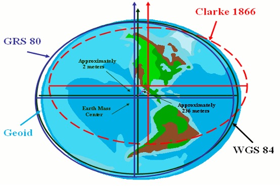
Common horizontal datums include NAD83 (North American Datum of 1983) and WGS84 (World Geodetic System 1984), which is used by satellite navigational systems worldwide. Each horizontal datum is based on a specific ellipsoid and origin. Because of this, the same physical point can have coordinates that differ by several feet depending on the datum used. Mixing data from different horizontal datums without proper transformation can lead to serious surveying errors.
Ellipsoids and Geoid
Datum science relies on two key reference surfaces:
- The ellipsoid is a smooth, mathematically defined shape that approximates the Earth and simplifies calculations. Ellipsoids form the foundation of most horizontal datums and are optimized for positional accuracy.
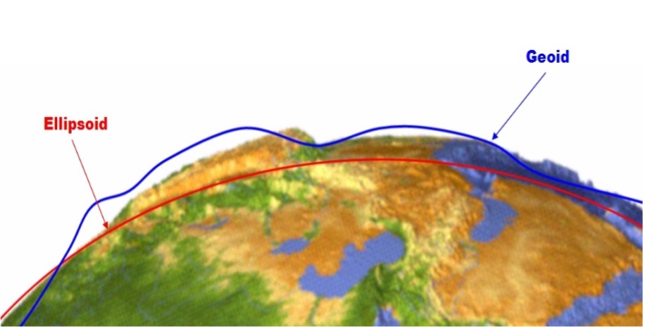
- The geoid is an irregular surface representing mean sea level influenced by the Earth’s gravity field. It rises and falls due to variations in mass distribution within the planet. Horizontal positions are referenced to ellipsoids, while elevations are referenced to the geoid. Converting between these surfaces requires precise gravity models and advanced computational techniques.
GPS and Modern Surveying
Global Navigation Satellite Systems have transformed land surveying, but they have also increased the importance of datums. GNSS receivers calculate positions relative to satellites and output coordinates based on a global datum, typically WGS84.
To achieve survey-grade accuracy, surveyors must transform GNSS data into local horizontal datums, apply geoid models to compute true elevations, and correct for tectonic plate motion. Many modern surveys rely on Continuously Operating Reference Stations (CORS) to maintain accuracy and consistency across large geographic areas. In brief, CORS is a permanently installed GPS/GNSS base station placed at a precisely known location.
It continuously receives satellite signals and sends correction data to surveyors in the field (usually through the internet). These corrections remove common GPS errors, allowing surveyors to achieve precise positional-level accuracy.
Using CORS eliminates the need to set up a temporary base station, making surveying faster, more efficient, and highly accurate.
 Datum Transformations and Errors
One of the most common sources of surveying error is improper datum transformation. Data from different datums can be mathematically correct within their own frameworks yet appear misaligned when combined, leading to incorrect boundaries, conflicting records, and potential legal disputes. Proper documentation and understanding of datums are therefore a professional, technical, and legal responsibility for surveyors.
The Evolution of Datums
 Datums are not static. As technology improves, datums evolve to reflect better Earth models and more precise measurements. Modern datums increasingly incorporate satellite observations, account for Earth’s motion over time, and use dynamic reference
 The Takeaway
Datums form the invisible but essential foundation of land surveying, allowing surveyors to accurately measure and represent positions on a complex, constantly changing Earth. By providing a standardized reference for location and elevation, datums ensure consistency between maps, boundary records, and engineering designs. Without a common datum, even precise measurements can conflict, leading to errors, misaligned boundaries, and costly disputes. As surveying technology advances through GNSS, and improved computational models, datums continue to evolve to reflect more accurate representations of the planet and its motion over time.
Understanding datum science is therefore not just a technical requirement but a professional responsibility. For surveyors, engineers, planners, and decision-makers, a strong grasp of datums ensures reliable spatial data, supports safe infrastructure development, and maintains confidence in the legal and practical frameworks that shape how land is measured, managed, and used.
Author: Cody Garrett
Cody brings 11 years of technical expertise and a strong commitment to precision in land surveying. He applies his skills across a wide range of projects, including ALTA/NSPS surveys nationwide, oil and gas pipeline work, topographic surveys, construction layout, M.U.D. and W.C.I.D. projects, ROW acquisition, drainage studies, and bathymetric surveys.
He is a TSPS Gulf Coast Chapter 9 board member, an organization dedicated to strengthening the land surveying profession through networking, continuing education, and community involvement. His experience and involvement reflect a dedication to advancing industry standards and collaboration.
Cody is AutoCAD certified and is a Surveyor in Training candidate actively pursuing licensure as a Professional Land Surveyor. He values accuracy, efficiency, and accountability, taking pride in delivering timely results that support sound project planning, reduce risk, and promote successful project execution.
Texas Survey Firm Registration Number 10020700
1904 W. Grand Parkway N., Suite 200, Katy, TX 77449
888-232-3149